


ENSO Alert System Status: El Nino Advisory
Click NOAA or IRI for current discussion of ENSO
El Nino conditions are present and expected to strengthen into the Northern Hemisphere winter 2026-27. There is a 63% chance of a very strong El Nino during November-January that would rank among the largest El Nino events in the historical record going back to 1950. CNN did an interesting reporton this potentially record-breaking event.
What is the El Nino-Southern Oscillation?
The El Nino-Southern Oscillation (ENSO) is one of the most important climate phenomena on Earth due to its ability to change the global atmospheric circulation, which in turn, influences temperature and precipitation across the globe. ENSO is series of linked weather- and ocean-related phenomena. Besides unusually warm or cool sea-surface temperatures, ENSO is also characterized by changes in atmospheric pressure. ENSO can often predict its arrival many seasons in advance of its strongest impacts on weather and climate.
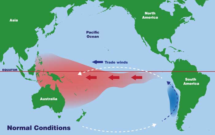
Though ENSO is a single climate phenomenon, it has three states, or phases, it can be in. The two opposite phases, El Nino and La Nina, require certain changes in both the ocean and the atmosphere because ENSO is a coupled climate phenomenon. Together, La Nina and El Nino are the cold (La Nina) and warm (El Nino) phases of the ENSO. Neutral is in the middle of the continuum. These three states are depicted below.
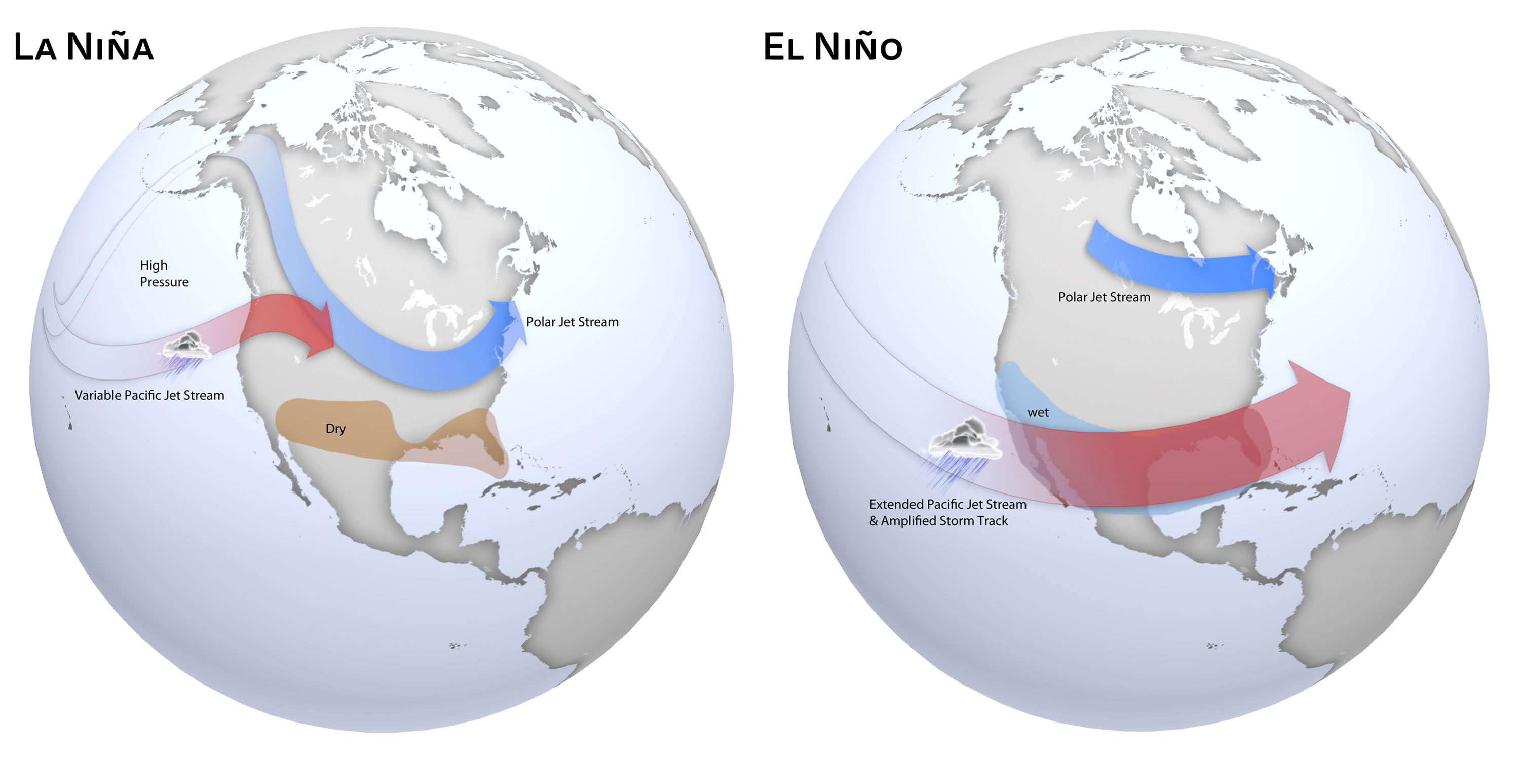
El Nino and La Nina also affects the jet stream as shown below.
Both El Nino and La Nina affect patterns of rainfall, atmospheric pressure, and global atmospheric circulation. Atmospheric circulation is the large-scale movement of air that, together with ocean currents, distributes thermal energy on the surface of Earth. These changes are the main sources of variability in climate for many areas worldwide.
During normal conditions in the Pacific Ocean, trade winds blow east to west along the equator, taking warm water from South America towards Asia. To replace that warm water, cold water rises from the depths in a process called upwelling. El Nino and La Nina are two opposing climate patterns that break these normal conditions.
El Nino and La Nina events tend to develop during the period Apr-Jun and they
- Tend to reach their maximum strength during October - February
- Typically persist for 9-12 months, though occasionally persisting for up to 2 years
- Typically recur every 2 to 7 years, on average, but they don't occur on a regular schedule
- Generally, El Nino occurs more frequently than La Nina
- Both phenomena tend to peak during the Northern Hemisphere winter
Warmer or colder than average ocean temperatures in one part of the world can influence weather around the globe. Watch this Ocean Today video below to see how this works.
Naming History
While ENSO is a nice catchall acronym for all three states, that acronym doesn't actually have the word La Nina in it. Why is that? Well, that is a fluke of history. Before La Nina was even recognized, South American fisherman noticed the warm up of coastal waters occurred every so often around Christmas. They referred to the warming as El Nino, (nino being Spanish for a boy child) in connection with the religious holiday.
Sir Gilbert Walker discovered the Southern Oscillation, or large-scale changes in sea level pressure across Indonesia and the tropical Pacific. However, he did not recognize that it was linked to changes in the Pacific Ocean or El Nino. It wasn't until the late 1960s that Jacob Bjerknes and others realized that the changes in the ocean and the atmosphere were connected and the hybrid term ENSO was born. It wasn't until the 1980s or later that the terms La Nina and Neutral gained prominence.
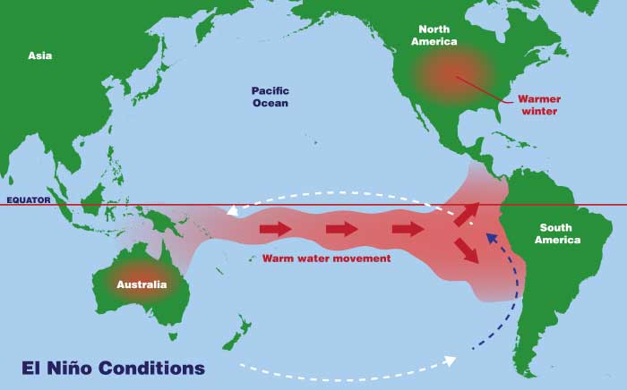
El Nino - Weakened Trade Winds and Warmer Eastern Pacific Waters
El Nino means Little Boy in Spanish. South American fishermen first noticed periods of unusually warm water in the Pacific Ocean in the 1600s. The full name they used was El Nino de Navidad, because El Nino typically peaks around December.
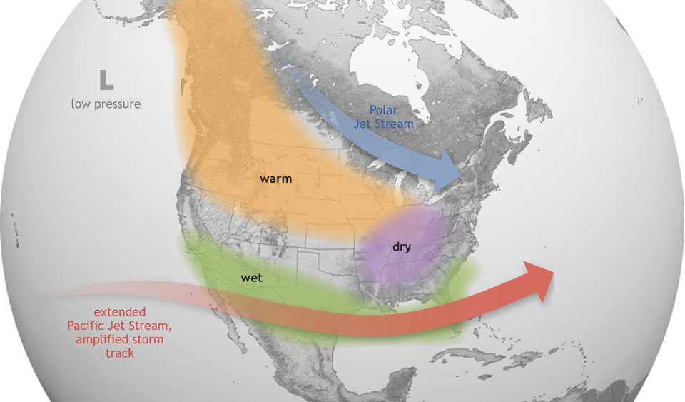
El Nino is a climate pattern that describes the warming of surface-ocean waters along the tropical west coast of South America. During El Nino, trade winds weaken. Warm water moves back east, toward the west coast of the Americas.
El Nino can affect our weather significantly. The warmer waters cause the Pacific jet stream to move south of its neutral position. With this shift, areas in the northern U.S. and Canada are dryer and warmer than usual. But in the U.S. Gulf Coast and Southeast, these periods are wetter than usual and have increased flooding.
Per the graphic below, El Nino causes the Pacific jet stream to move south and spread further east. During winter, this leads to wetter conditions than usual in the Southern U.S. and warmer and drier conditions in the North.
Below is a video from the New York Times:
El Nino also has a strong effect on marine life off the Pacific coast. During normal conditions, upwelling brings water from the depths to the surface; this water is cold and nutrient rich. During El Nino, upwelling weakens or stops altogether. Without the nutrients from the deep, there are fewer phytoplankton off the coast. This affects fish that eat phytoplankton and, in turn, affects everything that eats fish. The warmer waters can also bring tropical species, like yellowtail and albacore tuna, into areas that are normally too cold.
Over Indonesia, rainfall tends to become reduced while rainfall increases over the tropical Pacific Ocean. The low-level surface winds, which normally blow from east to west along the equator (easterly winds), instead weaken or, in some cases, start blowing the other direction (from west to east or westerly winds).
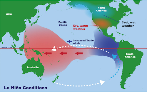
La Nina - Stronger Trade Winds Push Warm Water East, Upwelling Allows Cooler Water
La Nina means Little Girl in Spanish. La Nina is also sometimes called El Viejo, anti-El Nino, or simply a cold event. La Nina has the opposite effect of El Nino - La Nina is considered to be the counterpart to El Nino.
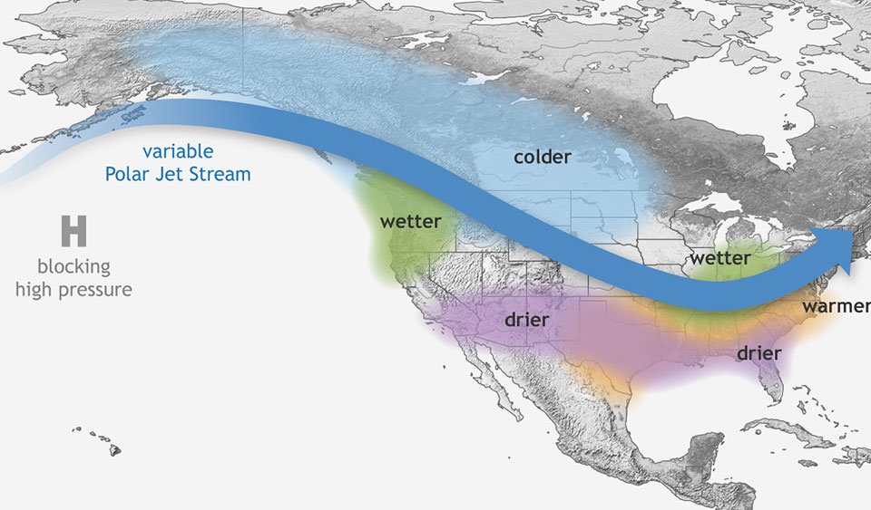
La Nina is a climate pattern that describes the cooling of surface-ocean waters along the tropical west coast of South America. During La Nina events, trade winds are even stronger than usual, pushing more warm water toward Asia. Off the west coast of the Americas, upwelling increases, bringing cold, nutrient-rich water to the surface. Upwelling can cause a drastic drop in sea-surface temperature. Coastal sea-surface temperatures near Ecuador and Peru dropped nearly 4 degrees Celsius (7 degrees Fahrenheit) during the 1988-89 La Nina event.
These cold waters in the Pacific push the jet stream northward. This tends to lead to drought in the southern U.S. and heavy rains and flooding in the Pacific Northwest and Canada. During a La Nina year, winter temperatures are warmer than normal in the South and cooler than normal in the North. La Nina can also lead to a more severe hurricane season.
Per the graphic below, La Nina causes the jet stream to move northward and to weaken over the eastern Pacific. During La Nina winters, the South sees warmer and drier conditions than usual. The North and Canada tend to be wetter and colder.
During La Nina, waters off the Pacific coast are colder and contain more nutrients than usual. This environment supports more marine life and attracts more cold-water species, like squid and salmon, to places like the California coast.
La Nina usually has a positive impact on the fishing industry of western South America. Upwelling brings cold, nutrient-rich waters to the surface. Nutrients include plankton eaten by fish and crustaceans. Higher-level predators, including high-value fish species such as sea bass, prey on the crustaceans.
Neutral - Neither El Nino or La Nina
Often tropical Pacific SSTs are generally close to average. However, there are some instances when the ocean can look like it is in an El Nino or La Nina state, but the atmosphere is not playing along (or vice versa).
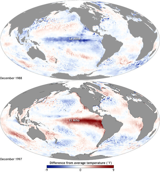
Sea Surface Temperatures of El Nino or La Nina
Maps of sea surface temperature anomaly in the Pacific Ocean during a strong La Nina (top, December 1988) and El Nino (bottom, December 1997). Maps by NOAA Climate.gov, based on data provided by NOAA View.
Alert System
On the second Thursday of each month, scientists with NOAA's Climate Prediction Center in collaboration with forecasters at the International Research Institute for Climate and Society (IRI) release an official update on the status of the El Nino-Southern Oscillation (ENSO). Here is a description of the categories and criteria they use.

Watch: Issued when conditions are favorable for the development of El Nino or La Nina conditions within the next six months.
Advisory: Issued when El Nino or La Nina conditions are observed and expected to continue.
Final Advisory: Issued after El Nino or La Nina conditions have ended.
Not Active: ENSO Alert System is not active. Neither El Nino nor La Nina are observed or expected in coming 6 months.
Monitoring ENSO
Scientists use the Oceanic Nino Index to measure the deviations from normal sea-surface temperatures that El Nino and La Nina produce in the east-central Pacific Ocean. La Nina events are indicated by sea-surface temperature decreases of more than 0.5 degrees Celsius (0.9 degrees Fahrenheit) for at least five successive three-month seasons.
Scientists collect data about El Nino and La Nina using a number of technologies. The National Oceanic and Atmospheric Administration (NOAA), for instance, operates a network of buoys which measure sea-surface temperature, air temperature, currents, winds, and humidity. The buoys are located in about 70 locations, from the Galapagos Islands to Australia. These buoys transmit data to researchers and meteorologists every day.
Using buoy data in conjunction with visual information they receive from satellites, scientists are able to more accurately predict ENSO and visualize its development and impact around the globe.
Sources:
NOAA-Climate.gov
NOAA-National Ocean Service
National Geographic
Columbia Climate School - International Research Institute for Climate and Society
NOAA SciJinks