Forecast Products - Outlooks, Advisories, Watches and Warnings
Sources: National Weather Service and ThoughtCo.
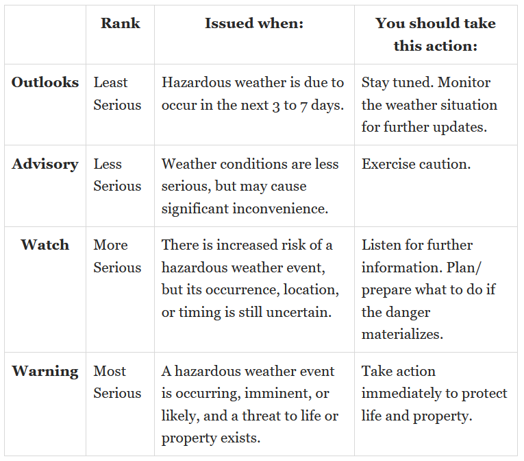
The National Weather Service (NWS) uses a notification system based on the increasing likelihood that a hazardous weather or water incident will occur. Starting with outlooks, advisories, then watches, and finishing with warnings. This notification system varies slightly by region depending on the type of hazardous weather that is likely to be experienced. In order from least to most threatening, the four-tier approach used by NWS to alert the public of weather hazards includes: outlooks, advisories, watches, and warnings.
Outlooks and advisories may be the least serious weather alerts, but that doesn't mean they'll always be issued first. Remember that there is no prescribed order for issuing advisories, watches, and warnings. In general, a watch and a warning for a single weather hazard cannot be issued simultaneously. Weather outlooks are one exception to this rule - they can be issued alongside an advisory, watch, or warning for the same weather hazard. When it comes to different weather hazards, there's no limit to the number of alerts that a forecast zone can be under. For example, an area could have an active blizzard warning, high wind warning, and windchill advisory in effect all at the same time.
NWS issues a Hazards Map which updates approximately every 5 minutes. The events are indicated on the map by different colors. Only one event per forecast zone can be shown on the map at a time, a forecast zone may have several warnings and watches in effect but only the most significant threat to life or property is displayed on the map. By clicking on the map to the forecast pages, you can read the text of all warnings, watches, etc. in effect for the forecast zone. You may view list of all warnings, watches, advisories, and statements that display on the maps and the associated color and color name.
Outlooks are issued for weather or water incidents that are expected to occur within the next 7-day period for conditions or an event that could result in a hazard, yet too far in the future for a watch, advisory or warning. The intention of outlooks is to increase public awareness of a potential hazard that may affect life and property.
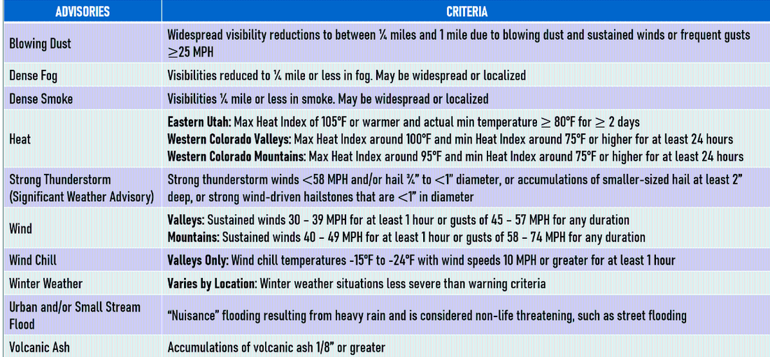
Advisories highlight special weather conditions that are less serious than a warning. They are for incidents that may cause significant inconvenience and, without due caution, could lead to a dangerous or threatening situation.
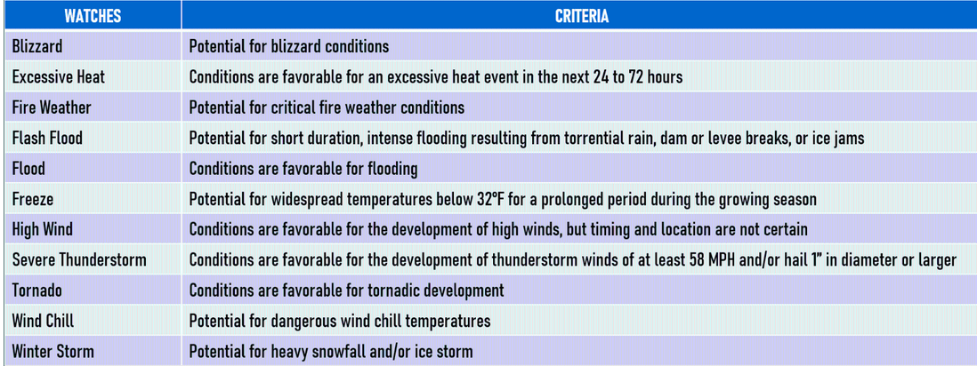
Watches are issued 2 to 24 hours in advance of potentially hazardous weather or water incidents, allowing the community time to plan. Watches for long fused events, such as winter storms or river flooding, may be issued up to 2-3 days before the onset of expected dangerous weather conditions. A watch indicates the risk of a hazardous incident has increased significantly but its occurrence, location, and/or timing is still uncertain.
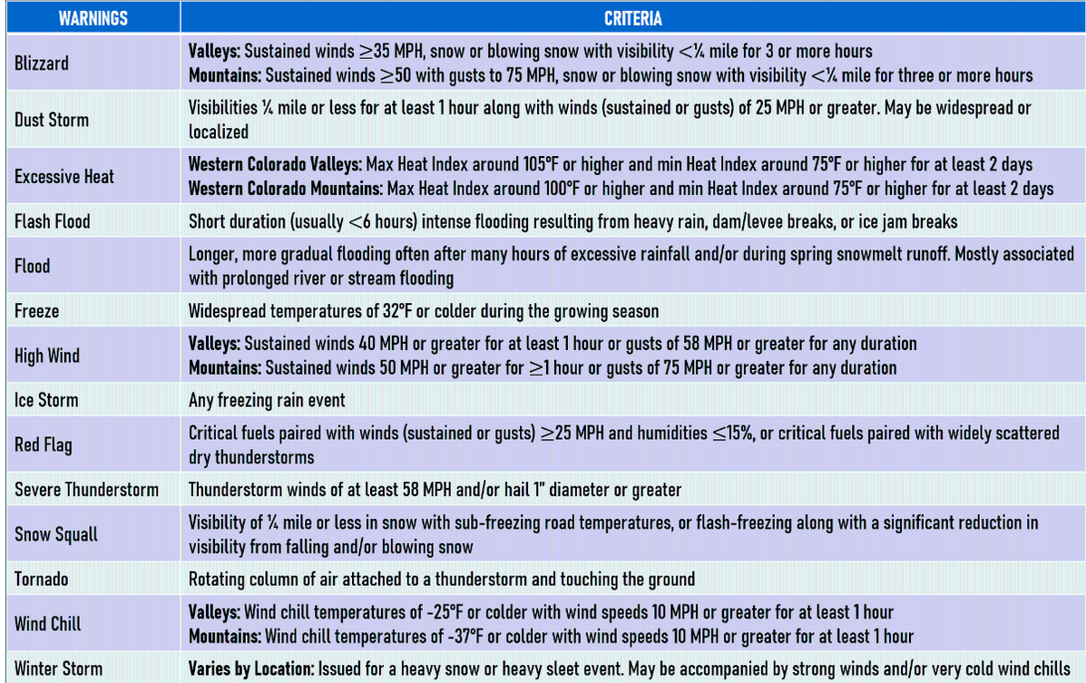
Warnings are more serious than advisories. When severe or hazardous weather is occurring, imminent, or poses a threat to lives and/or property, forecasters issue warnings. Warnings also include brief guidance on taking protective measures.